Showing posts with label Andersen. Show all posts

Monday, April 05, 2021

Geology Through Literature - Han Christian Andersen's: The Comet

Geology Through Literature: 

Hans Christian Andersen's: The Comet (1869)


And we have finally reached the ninth and final entry of Hans Christian Andersen's geological references.

For other Geology Through Literature entries, please check them out compiled on my website.

The Comet (1869)

Comets
Now there came a comet with its shiny nucleus and its menacing tail. People from the great castles and people from the poor huts gazed at it....

But a little boy and his mother still stayed inside their room. The mother believed ... that her son would soon die. The little boy lived many more years on earth. Indeed he lived to see the comet return sixty years later.

...

"This is the time to look at the comet," cried their neighbors.... 

The boy saw the bright ball of fire, with its shining tail. Some said it was three yards long, while others insisted it was several million yards longsuch a difference.

In general a comet is is a body of ice, rock, and organic compounds that can be up to several miles in diameter. "Comets are thought to originate from a region beyond the orbits of the outermost planets. Scientists believe that gravitational perturbations periodically jar comets out of this population, setting these "dirty snowballs" on orbital courses that bring them closer to the Sun. Some, called long-period comets, are in elliptical orbits of the Sun that take them far out beyond the planets and back. Others, called short-period comets, travel in shorter orbits nearer the Sun" (Nasa.gov).

Comet 153P/Ikeya-Zhang which has the longest known tail at over a billion kilometers. Image courtesy of NewScientist.

Although many comets are known to have a return period, much of the comets with known return periods had only been discovered fairly recently. There are two types of comets based on their orbital periods; known as long-period comets, which are comets with orbital periods greater than 200 years, and short-period comets, with orbital periods less than 200 years. Even the short-period comets can be broken up into Halley-Type comets, which have orbital periods between 20 and 200 years, and Jupiter-family comets, that have orbital periods less than 20 years. 

Besides Halley's comet, which was determined in 1705 by Edmund Halley to return at a set amount of time (75-76 years), there aren't many comets that have been identified with periodic return periods. To date, only ~300 periodic comets have been identified, with less than 10 identified by the publication of this story (1869). 

The problem with identifying these comets is that typically only bright comets are easily identified in the sky, especially by the naked eye. These bright comets, often called "Great Comets", however usually need to be fairly large, pass closely to the sun, and pass closely to earth. Although these bright comets are bright enough to be seen by the human eye, their close approach to the sun often can spell disaster for the comet, reducing it to space dust. So many of the Great Comets are one time affairs. Halley's Comet being the exception of a bright comet that continues to have a periodic return.

Within the story Andersen seemed to take the appearance of a bright comet and a periodic comet and mixed them with his own tale of a man that would live another 60 years. To date there is only one comet with an approximate return periods of 60 years, and that was only discovered in 2015. This comet, C/2015 F5 (SWAN-XingMing), has a return period of 60.9 years and was only barely visible due to its mostly lack of a tail. 

The Great Comet of 1861 as painted by E. Weiss. Image courtesy of Wikipedia

The Great Comet of 1861 (C/1861 J1) would probably be the closest great comet to the time of publication. Although, as I said that many of the Great Comets are destroyed, it appears that this comet was linked with other pervious comets and had been determined to have an orbit of 407 years. As more time passes and more of the historical records are analyzed it will likely come that even more of the previously thought one-off comets will be determined to be linked, and/or have a periodicity themselves.

Andersen makes note of the length of the comet tail, in which I assume is a difference between looking at in in the sky (three yards long) and thinking of it in its real life length (several million yards long). In real life, the tail is created when solar winds and solar radiation pressure blows ionized gasses and debris off of the comet. This causes the tail to always be pointed away from the sun. Since the tail is a product of the sun, the closer to the sun that the comet gets, the longer and brighter that the tail gets. And there are actually two tails on a comet, the blue tail is formed from the ionized gasses blowing off the comet ball while the white/pink tail is from the small dust particles. 

Typical visible comets can get a tail that can reach up to 150 million kilometers, much more than even the high-end length noted in the story. And as can be seen in the top picture here, the length of the tail can even get to over a billion kilometers in length. 

Sunday, April 04, 2021

Geology Through Literature - Han Christian Andersen's: The Rags

Geology Through Literature: 

Hans Christian Andersen's: The Rags (1868)


We continue on to the eighth, and penultimate entry, of Hans Christian Andersen's geological references.

For other Geology Through Literature entries, please check them out compiled on my website.

The Rags (1868)

Bedrock Geology
"I am Norse!" said the Norwegian. "And when I've said I'm Norse I guess I've said enough. I'm firm of fiber, like the ancient granite rocks of old Norway. The land up there has a constitution, like the free United States. It makes my fibers tingle to think what I am and to sound out my thoughts in words of granite!"

 Norway's bedrock is truly ancient by no exaggeration of the term. The oldest rocks in Norway are part of the Fennoscandinavian shield, which are the Scandinavian Precambrian bedrock, the oldest rocks of which can be found along the northern edges of the country in Finnmark, Troms, and Vesterålen. These oldest rocks date back almost 3 billion years old.

The oldest rock in Norway at 2.9 billion years old. Image courtesy of the Geological Survey of Norway.

As you can see in the map below, most of these truly ancient parts of the Scandinavian shield are in the Finland and Russian parts of the Fennoscandian Peninsula. 

Bedrock geology of Scandinavia. Image courtesy of the Geological Survey of Norway

The vast majority of Norway is underlain by incredibly old rocks, even those parts not in the northernmost regions. The question now is, are these rocks truly granites like the text says? Granite is often a term used as an all encompassing term for crystalline rocks. Just look at the countertop industry where everything is "granite" where much of the counter tops are not actually granite by the geological definition of the word. 

Granite is an intrusive igneous rock that formed from the cooling of magma deep within the earth where the earth insulated the magma allowing to cool slowly. The slow cooling allowed the mineral crystals within the rock the time to grow creating the crystalline rock so well known as granite. The naming of an igneous rock is dependent on how the rock formed (intrusive versus extrusive) and what the mineral composition is, essentially how much quartz is there in the rock. To identify the rocks there is a chart/scale of intrusive igneous rocks which are identified based on the silica (quartz) content. 

Basic Intrusive Igneous Rock Scale 

On the high end of the scale with a high quartz/silica content is Granite, known as a felsic rock. In the middle, with an intermediate amount of quartz/silica, is Diorite. And on the low end of the scale with no quartz/silica is Gabbro and Peridotite. Igneous rocks with no silica are known as mafic rocks.

Really old rocks also have more instances where they can get metamorphosed. This means that they had been subject to increased heat and/or pressure. When that happens, the minerals within the rock change. The rocks don't fully melt, but the increased heat allows the elements within the rock to reorganize themselves forming new rocks. When granite is metamorphosed, it produces a metamorphic rock known as a gneiss (pronounced "nice"). Gneiss is the rock most often miscategorized as a granite, since they so often resemble one another, however there is a mineralogical and a structural difference between the two. 

Portion of the Geological Map of the Fennoscandian Shield showing northern Norway. Circled rocks represent the oldest (Archaean rocks identified as "462") in Norway. Image courtesy of GigaPan.

Looking at a much more detailed geological map in the Fennoscandinavian shield, it turns out that oldest rocks within the Norwegian portion of the shield are indeed composed of granites and gneisses. The northernmost coastal rocks in Norway are identified on the geological map of the region as "462", these are Archaean granite, granodiorite, tonalite, and metamorphic equivalents. The other rocks of similar age are identified as "463", and these are migmatitic gneiss of granodioritic to dioritic composition. 

Being so old, the rocks only represent the basement of the region and have several billion years of rock history deposited on top of them. They record the history of mountains built up, eroded down, built up again, and eroded down again. There is more history in these basement rocks than most rocks will ever see in their lifetime before they are broken down by the passage of time. So, like Andersen said, the northern portions of Norway really do contain "ancient granite rocks".

Saturday, April 03, 2021

Geology Through Literature - Han Christian Andersen's: Vano and Glano

Geology Through Literature: 

Hans Christian Andersen's: Vänö and Glänö (1867)


For the seventh entry we continue on through Hans Christian Andersen's oeuvre to our next geological reference.

For other Geology Through Literature entries, please check them out compiled on my website.

Vänö and Glänö (1867)

Shoreline Geology

Near the coast of Zealand, off Holsteinborg castle, there once lay two wooded islands, Vänö and Glänö, on which were villages, churches, and farms. The islands were quite close to the coast and quite close to each other; now there is but one of these tracts remaining.

One night a fierce tempest broke loose. The ocean rose higher than ever before within man's memory. The storm increase; it was like doomsday weather, and it sounded as id the earth were splitting...

That night Vänö vanished into the ocean depth; it was if that island had never existed. But afterward on many a summer night, when the still, clear water was at a low tide, and the fisherman was out on his boat to catch eel by the light of a torch, he could, on looking sharply, see Vänö, with its white church tower and high church wall, deep down below.

...

You went away from there ... and after a few years you have returned.... Where is Glänö? You don't see little wooded island before you; you see only open water. Has Vänö finally taken Glänö, as it so long was expected to? On what stormy night did this happen, and when did an earthquake move old Holsteinborg so far inland?

There was no stormy night; it all happened on cleat sunny days. Human skill built a dam to hold back the ocean; human skill dried up the water and bound Glänö to the mainland. The bay has become a meadow with luxuriant grass; Glänö has become part of Zealand. 

If you try and search for the word "Glänö", most of the results are just for references to this specific story. However, I was able to find a bit for information after doing a search for the Holsteinborg castle, which does exist. 

Google Maps of Holsteinborg Castle showing Glænø Island.

Based on the map of the castle, there sure enough appears to be an island, directly next to Holsteinborg Castle called Glænø. I feel this is far too close a coincidence to be happenstance. However, in the story, it specifically states that the island of Glänö was dammed up and incorporated into the mainland. Even though the map above doesn't appear that the island is not an island, let's look at the aerial photo to see if things get any clearer. 

Aerial Photo of the area around Holsteinborg Castle. Image courtesy of Google Earth

Here we can see a lot more sediment build up in the estuary behind the island, and that is because of the dam that is built to the island. In the picture here and above, the road that leads to the island on the northwest corner is on top of a 100 meter long dam. So, as the story stated, the residents built a dam, essentially merging the island with the mainland.

But where could Vänö (also spelled Vænø) be then?

There are a couple of theories that I have. My first theory is that the island directly next to Glænø, Østerfed could be a new name for the island. However, since this is clearly still an island, my guess is that this is not what we are looking for.

If this is not Vänö, then the island must once have resided within the bay to the south of Glænø called  Smålandsfarvandet. If we look a bit further out from Glænø into the bay, there is an island with a similar sounding name.

Smålandsfarvandet aerial image courtesy of Google Earth.

The island, Vejrø, does have a similar name, however based on the description, the island is not really "quite close", nor "near the coast". It is also not a sunken island. So, my last theory is that the island truly was sunk off the coast somewhere. But if it was, there is likely evidence in the bathymetry of the bay. There should be some sort of raised island under the water, as other parts of the text describe that the island is still visible on calm water days.

Although there are not a lot of publicly available bathymetry charts of Smålandsfarvandet, I did find a few that offered glimpses that there is a submerged land area about halfway between Glænø and Vejrø. As can be seen in the following bathymetry chart. 

Bathymetry map off the southern shore of Glænø. Image courtesy of Kroon et al., 2015.

A little further investigation and it turns out this shallower area of the bay on the southern edge of the map above is actually a reef. It is known as the Kirkegrund Reef and parts of the reef reach as low as 1-2 meters below sea level (~5 feet). 

Cross section of the Kirkegrund Reef. Image courtesy of Stæhr et al., 2016.

The cross section above shows shallow areas around 6 meters below sea level, however other maps show a significantly shallower region in other parts of the reef. The further back in time that we go, the lower sea level was, so perhaps this was the island that Andersen was referring to. If we think that this island was once Vänö, then it is possible that legends grew up about this island off the coast that eventually was swallowed up by a big storm. And the things that the fishermen were seeing off shore was actually the reef far below the surface and not the remnants of various buildings once build on the island.

Friday, April 02, 2021

Geology Through Literature - Han Christian Andersen's: The Ice Maiden

Geology Through Literature: 

Hans Christian Andersen's: The Ice Maiden (1861)


For the sixth entry we continue on through Hans Christian Andersen's oeuvre to our next geological reference.

For other Geology Through Literature entries, please check them out compiled on my website.

The Ice Maiden (1861)

Glaciers

They had made the greater part of the journey, had climbed the highest ridges to the snowfields and could already see her native valley with the familiar scattered cottages; they now had only to cross the upper part of one great glacier. The newly fallen snow concealed a crevasse, not deep enough to reach the abyss below where the water rushed along, but deeper than a man's height... 

The glacier lies like a rushing stream, frozen and pressed into blocks of green crystal, one huge mass of ice balanced on another; the swelling stream of ice and snow tears along in the depths beneath, while within in it dwells the Ice Maiden, queen of the glaciers. 

Glaciers are essentially as Andersen describes them, big piles of ice that slowly move across the landscape. Mountain glaciers in particular are known for flowing down valleys, like rivers. In the upper part of the mountains, where it is colder, snow builds up over time. As more and more snow is dropped on the top of the mountain, eventually it starts to get compacted in the vertically lower layers, forming ice. As more and more ice builds up, the glacier starts to flow, like molasses, down the valleys. As the glacier moves down the valleys, the ice picks up and freezes small and large pieces of rocks and drags them along on the bottom of the ice. These rock fragments then grind down into the bedrock over which the glacier flows. Eventually the glacier reaches an elevation where it is too warm for the ice to remain frozen all of the time (like in the upper regions) and it starts to melt. Towards the end of the glacier where all of it has melted away, it acts like a conveyor belt, carrying all of the debris it eroded away and piling it up into one big pile of glacial debris called a moraine. 

Glacial meltwater pathways. Image courtesy of Antarctic Glaciers

Due to differences in temperature from the upper surface of the glacier and the bottom depths, the upper layers will sometimes melt from warming by the solar rays. This occurs even in the coldest of temperatures due to the ability of the sun's energy to melt the ice. This melted water then flows down into the glacier through large cracks in the ice known as crevasses. This meltwater will sometimes then flow all the way to the base of the glacier along the bedrock where streams can be formed.  

Snow covered crevasse. Image courtesy of SwissEduc.

Also as the glacier moves, the whole glacier may not always flow as one solid, cohesive unit. Going over uneven terrain, or variations in the width of the valley, will alter how the glacier flows. These flow changes then have the potential to crack the ice. These cracks are known as crevasses, and sometimes the crevasses can go from the surface all the way to the base of the glacier, which in some instances could be hundreds to thousands of feet thick. These crevasses are also often covered over with a thin layer of snow due to variations in movement of the ice. These thin crusts, or bridges, of snow make walking across the surface of a glacier a very dangerous thing to do if you don't know what you are doing.

References

Thursday, April 01, 2021

Geology Through Literature - Han Christian Andersen's: A Story from the Sand Dunes

Geology Through Literature: 

Hans Christian Andersen's: A Story from the Sand Dunes (1859)


For the fifth entry we continue on through Hans Christian Andersen's oeuvre to our next geological reference.

For other Geology Through Literature entries, please check them out compiled on my website.

A Story from the Sand Dunes (1859)

Shoreline Erosion
Still, it is easy to imagine yourself back in times more remote than even the reign of Christian VII, for now, as then, the brown heath of Jutland stretches for miles with its barrow, its mirages, its winding, rough, sandy roads. To the west, where broad streams flow into the fjords, there are marshes and meadows, encircled by the high sand hills which rise up toward the sea like an Alpine chain with jagged summits, broken only by high banks of clay. From these the waves eat off giant mouthfuls year after year, so that the edges and summits topple down as though shaken by an earthquake. That's how it looks today, and that's how it looked many years ago...

 The passage describes the persistent erosion along the western shore of Jutland, a region of Denmark, with Western Jutland bordering the North Sea. 

Map of Jutland, Denmark. Image courtesy of Wikitravel.

The beaches and the sand dunes of the Jutland coast were deposited during the last Ice Age consisting of clay and fine sand that total 100 meters of sediment deposited over 100,000 years. These deposits are known as the Skærumhede series.

The Jutland western shore. Image by Lucia Margheritini and courtesy of Science Nordic.

These sediments make up much of the western coast, but they are slowly being transported out to sea due to coastal erosion. As the cliff faces are worn away at the bottom, the upper layers eventually collapse and then are carried away by the waves. Much of the erosion occurs during the winter months when the water levels are higher and storm levels are stronger, producing winds and waves capable of wearing away at the cliff face that is otherwise out of reach during calm, summer days. 

The sediment along the coast is then transported through the longshore current from south to north. However, the amount of sediment removed is more than the sediment supplied by the current, so the coastline is in a losing scenario. It is estimate that it has been in a losing scenario since the last ice age, ~10,000 years ago. 

And although this erosion has been continuing since long before and after Andersen's time, the current rate of erosion has been increasing. There are several reasons for this but mainly they can boil down to manmade impacts and climate change. Structures on the beach, scientists know, have a tendency to alter the erosion patterns, often producing more erosion in areas beyond where the structure are built. Think dams and sea walls. These structures stop erosion where they are built, but the lack of sediment within the water beyond these points allows for more erosion than would otherwise occur. With climate change there are many reasons for potentially accelerated erosion including: more and/or stronger storms, rising sea levels, and changes in weather patterns. It is estimated in this region that the changes in weather patterns, specifically more rain, has been the cause of the accelerated erosion, with the increased rain breaking down the cliff edges more readily than they were before. 

References

Wednesday, March 31, 2021

Geology Through Literature - Han Christian Andersen's: Beautiful

Geology Through Literature: 

Hans Christian Andersen's: Beautiful (1859)


For the fourth entry we continue on through Hans Christian Andersen's oeuvre to our next geological reference.

For other Geology Through Literature entries, please check them out compiled on my website.

Beautiful (1859)

Eruptions

It was a delight to hear Mr. Alfred speak. He told them of Naples, of trips to Mount Vesuvius, and showed them colored prints of some of the eruptions. The widow had never heard of such things before, much less taken time to think about them.

"Mercy save us!" she said. "So that's a burning mountain! But isn't it dangerous for the people who live there?"

"Entire cities have been destroyed," he answered. "For example, Pompeii and Herculaneum."

"Oh, the poor people! And you saw all that yourself?"

"Well, no, I didn't see any of the eruptions shown in these pictures, but I'll show you a drawing I made of an eruption I did see."

He laid a pencil sketch on the table, and when Mamma, who had been studying the highly colored prints, glanced at the black-and-white drawing, she cried in amazement, "When you saw it did it throw up white fire?"

For a moment, Alfred's respect for Kala's mamma nearly vanished; but then, dazzled by the light from Kala, he decided it was natural for the old lady to have no eye for color. After all, it didn't matter, for Kala's mamma had the most wonderful thing of all—she had Kala herself.

We head back to Mount Vesuvius, as we talked about previously with the What the Moon Saw story. The only thing to add here of note was that Herculaneum was also well known by this time, with the excavation actually having started before the excavation of Pompeii in 1748. Herculaneum itself was discovered after Pompeii, in 1709, and systematic excavation beginning in 1738, a full decade before Pompeii. The note in the text about Mr. Alfred showing Mamma the "colored prints", I must assume that he means copies of colored paintings and drawings, since colored photography had yet to be invented. 

Vesuvius in eruption, April 26, 1872. Original caption 'from a photograph taken in the neighbourhood of Naples''. (Palmieri and Mallet, 1873). Image courtesy of Oxford Sparks

However, an interesting note is that the first photograph of a volcanic eruption is believed to be the 1972 eruption of the very same Mount Vesuvius, which aided the Director of the Vesuvius Observatory, Luigi Palmieri, to document the eruption with a dramatic line drawing. 

References

Tuesday, March 30, 2021

Geology Through Literature - Han Christian Andersen's: Ole The Tower Keeper

Geology Through Literature: 

Hans Christian Andersen's: Ole, The Tower Keeper (1859)


For the third entry we continue on through Hans Christian Andersen's oeuvre to our next geological reference.

For other Geology Through Literature entries, please check them out compiled on my website.

Ole, The Tower Keeper (1859)

First Visit
Listening to the Rocks
Among the books I had recently lent Ole was one about pebbles, which had greatly pleased him.

"They are truly veterans from olden times, those pebbles," he said, "yet people pass them by without thinking, and trample them down in fields or on beaches, those fragments of antiquity. I have done so myself. From now on I shall hold every paving stone in high respect!...

"The romance of the Earth is truly the most fascinating of all romances. It's a shame we can't read the first parts of it; but they're written in a language we haven't learned yet; we have to dig away among strata and rocks, puzzling out bits here and there from the early acts of earth's drama.... The crust on which we move remains solid so that we never fall through, and so it is a story of millions of years, with steady progress. 

"Many thanks for your book on pebbles; those old fellows could tell us so much if only they could talk.... And it makes you feel so ridiculously young, compared with the millions of years of these venerable stone!"

"...I was rolling through millions of years with my rocks, watching them break loose up in the North, drift along on icebergs ages before on a reef, and at last peer up through the water and say, 'This shall be Zealand!'..." 

What Andersen is describing is exactly what geologists hope to decipher. Geologists read the rocks. They listen to what the rocks have to say and have been doing it far before Andersen's time period. Which he should be aware of with his comments about the earth being millions of years old, since geologists are the reason that we even thought that the earth was millions of years old at that time (we now know it to be ~4.543 billion years old).  

Layers of the Earth

The scientist that is often touted as the father to modern geology is James Hutton, who lived from 1726 to 1797. He is the one who came up with some of the first principles of geology, which are his way of essentially listening to what the rocks had to tell us. James Hutton's primary theory that he developed was the Principle of Uniformitarianism, which stated that the present is key to the past and that all processes happening on Earth today are the same ones that happened on the Earth in the past. This means that when we have ripples and mud cracks in modern day sediments, they can help us identify ripple marks and mud cracks in the rock record. Since everything happening today has happened in the past and erosion and deposition are incredibly slow processes then the age of the Earth must be very, very old. Although he couldn't be sure of an exact age of the Earth, one could easily assume the Earth was millions or even billions of years old based on the rates of modern day erosion and sedimentation.

His research continues today with geologists "reading the rocks" and listening to their life stories. Then taking this information and combining it with the histories of other rocks, until we have a full and complete global history dating back to the beginning of the earth. We aren't fully there yet, and we may never get fully there, but it is an ever hopeful promise that we may.

Shooting Stars

"Then three or four beautiful shooting stars fell; they shone brightly, and started my thoughts off in an entirely different direction. Does anybody know what a shooting star really is? The learned do not know!..."

Although Andersen claims that the "learned do not know", we do know today what they are. They are bits of cosmic debris that burns up when it enters our atmosphere, technically called a meteor. The meteor is the flash of light that we see when the debris enters the atmosphere and the debris itself is called a meteoroid. 

Illustration of a "fireball" from a 1771 publication by Le Roy (Marvin, 2007). 

What interests me about this statement is when did scientists begin to learn about meteors and shooting stars. One of the first scientists to suggest that the fireballs were real events was Ernst Chladni in 1794. He hypothesized that shooting stars, fireballs that came crashing to earth, and the physical meteorites were all related phenomena. Although there was resistance to the idea at the time, he persevered until his death in 1827. It was not until 1834, that scientists had been able to start piecing together that meteor showers were tied to specific orbital events, and from here to realize that shooting stars were actually pieces of orbiting materials burning up in the atmosphere. 

It took until 1862 when the hypothesis that shooting stars had an extraterrestrial origin had firmer proof with the prediction and the tying of comets to specific orbits and times of the year. With these observations, future meteor showers were able to be predicted including the 1866 Leonid shower. So, even though the story was written in 1859, there still was significant evidence at that point that meteoroids were the cause of the shooting stars with firmer proof only a few years away.  

References

Monday, March 29, 2021

Geology Through Literature - Han Christian Andersen's: What the Moon Saw

Geology Through Literature: 

Hans Christian Andersen's: What the Moon Saw (1839-1840)


For the second entry we continue on through Hans Christian Andersen's oeuvre to our next geological reference.

For other Geology Through Literature entries, please check them out compiled on my website.

What the Moon Saw (1839-1840)

Twelfth Evening
Mount Vesuvius
"I shall give you a picture of Pompeii," said the Moon. "I was outside the city, in the Street of the Tombs, as they call the place where happy youths, with wreaths of roses on their heads, once danced with the fair sisters of Lais. Now the silence of death reigns there.

"German soldiers in the service of Naples kept guard, and played cards and diced. A group of strangers from beyond the mountains walked into the city, conducted by a guard. They had come to see, in the full clear rays of my light, the city arisen from the grave. I showed them the ruts of the chariot wheels in the streets paved with great slabs of lava. I showed them the names upon the doors and the signs still hanging before the houses. In the narrow courts, they saw the fountain basins ornamented with shells, but the waters no longer spouted forth. No longer were songs heard from the richly painted chambers, where the bronze dogs kept watch before the doors. It was the City of the Dead. Vesuvius alone still thundered his eternal hymn, and each stanza of it men call a new eruption. We visited the Temple of Venus, built of pure white marble, with its high altar in front of its broad steps; the weeping willow has sprung up between the columns. The air here was transparent and blue, and in the background loomed Vesuvius, black as coal, its flames rising straight as the trunk of a pine tree. The glowing smoke cloud lay in the still calm of the night like the crown of the pine tree, but red as blood."

As is relatively well known, the city of Pompeii, located 14 miles to the southeast of Naples, was buried in ash after the eruption of the volcano Mount Vesuvius in 79 AD. This eruptive cloud of  heated gasses, ash, and other pyroclastic debris asphyxiated the populace and buried it in ash, preserving the town, and the people, to this day. As noted in the text, even the ruts in the streets were preserved. 

The street Via dell'Abbondanza in Pompeii with the street car ruts visible. Image courtesy of Britannica.

The city itself was also built on top of lava flows, being located very close to the volcano. Vesuvius, although not historically active prior to 79 AD, is a very active volcano. The people of Pompeii and surrounding towns likes Herculaneum were unaware of the danger that they were in but just being in the vicinity of the mountain. That time has passed and now people are fully aware of the hazards in the area, many of those from the repeated eruptions of Vesuvius since 79 AD. 

The ruins of Pompeii were discovered in the late 16th century with excavation work on the city beginning in 1748 under the patronage of the king of Naples, Don Carlos, carried out by the military engineer Karl Weber. During this time, the excavations were haphazard and often by untrained treasure seekers. 

As noted in the excerpt, these excavations took place in the shadows of eruptions by Vesuvius, with eye witness accounts describing the very same pillar of fire erupting from the volcano itself during this time. Between the time the excavations started (1748) and the time the story was published (1840), there were 7 separate periods of volcanic activity, with several containing "pillars of flame". The most recent one to the publication in January of 1839 had this event described: 
Outflow on 31 Dec 1838. At dawn of 1 Jan 1839, dark eruption column, lava flow to W . Between 1 and 4 Jan, fracture of the cone to E and W, on 2 Jan high white cloud; then lava to E (Boscotrecase) and W (Canteroni); lava fountains up to 400 m, and black ash on Boscotrecase and Castellammare. After the eruption the crater was funnel-shaped with a diameter of 700 m and a depth of 285 m (Pilla, Baratta) (Courtesy of MTU.edu)

And not only are there written descriptions, but visual recreations in the forms of paintings from the time. Below are  pictures of eruptive columns from the 1788 eruption and the 1822 eruption.

Vesuvius from Posillipo by Joseph Wright of Derby, painted ~1788. Image courtesy of Wikipedia.

Vesuvius in eruption, October 1822. George Poulett Scrope, Considerations on Volcanoes, 2nd ed. (1864), frontispiece. Image courtesy of the BBC.

So, it would appear that Andersen was very well informed with the geological activity going on during his time.

References

Sunday, March 28, 2021

Geology Through Literature - Han Christian Andersen's: The Galoshes of Fortune

Geology Through Literature: 

Hans Christian Andersen's: The Galoshes of Fortune (1838)


Despite this not being my favorite book I ever read, or even anywhere near an enjoyable book, there were actually quite a bit of geological references sprinkled through Andersen's publishing history. Andersen was also fairly accurate in a lot of his geologically descriptive passage that are still accurate to this day, even almost 200 years later. Since there are so many geological references throughout his fairy tale career, I have decided to do a post for each one that I am going to cover. 

For other Geology Through Literature entries, please check them out compiled on my website.

The Galoshes of Fortune (1838)

Part III. The Watchman's Adventure
The Speed of Light
"But all this is like the gait of a sloth, or the pace of a snail, in comparison with the speed of light, which travels nineteen million times faster than the fastest race horse.... The sunlight takes eight minutes and some odd seconds to travel nearly one hundred million miles."

The speed of light has currently been measured to be 3 x 10^8 meters per second (or more accurately 299,792,458 m/s). 

The maximum speed of a race horse is ~44 miles per hour, or ~0.122 miles per second.

Converting, the speed of light is therefore ~670,000,000 miles per hour, or ~186,000 miles per second.

The speed of light then works out to ~15 million times the speed of the fastest race horse. Of course you must take into account that perhaps the fastest race horse of today is not the same as the ones in the mid-1800's. So if you had a race horse with a top speed of 35 miles per hour, then indeed, the speed of light would be 19 million times faster.

My big question here though, was when was the speed of light determined? This story was published several decades before Einstein, so who discovered how fast light moves and how?

The speed of light was actually determined almost 350 years ago. In 1676, the Danish astronomer Ole Roemer was studying Jupiter's moon Io. By studying the length of the eclipse during different times of the year, Romer hoped to determine an accurate orbital period of the moon. The orbital period, determined to be 1.769 Earth days, was watched by Romer over many years and he noticed that the time intervals between eclipses wasn't consisted. As the Earth moved towards Jupiter, the eclipses came earlier. As the Earth moved away from Jupiter, the eclipses came later. He estimated that there was a difference of 22 minutes between the two extremes. The cause of this delay, he determined, was the time that the light needed to cross space from the closer orbital point to the further orbital point. Dividing this time by the diameter of Earth's orbit, should give a fairly accurate value for the speed of light.

Illustration of how Romer determined the speed of light from the time of Io's eclipse. Image courtesy of AMNH by Diana Kline

This calculation was done by Dutch scientist Chistiaan Huygens, finding the value to be 131,000 miles per second (off by about 30%). The difference from the true value was due to inaccuracies in the time calculation by Romer (actually 16.7 minutes, not 22) and imprecise knowledge of the Earth's orbital diameter. Even with the incorrect speed determined, he was at least within the correct ballpark and his method for determining the speed of light was accurate.

The Moon

In a few seconds the watchman took in his stride the 260,000 miles to the Moon. As we know, this satellite is made of much lighter material than the earth, and is as soft as freshly fallen snow. The watchman landed in one of the numerous mountain rings that we all know from Doctor Maedler's large map of the Moon.

The novel Vanity Fair, happened to also bring up the topic of the distance to the moon and was published about 10 years after this book. I had broken down the early history of how the distance to the moon was calculated there

For here I wanted to focus on three things. The first is the assumption here that the moon was made of a much lighter material than the Earth. We now know that the moon not made of softer and lighter stuff than the Earth, it is actually made of the same rocks as the Earth, and that is because it was formed from the Earth. Early in the history of the Solar System, there was a proto-Earth and another planet known as Theia. Theia crashed into Earth in its early history, melting both planets and combining them into one with a much smaller mass spinning off to form the moon. Because of this, chemically speaking, the moon is identical to the Earth. However, over time as the Earth has aged, it's rocks have differentiated from each other to produce varying rock types in different environments and depths, whereas the moon, being far smaller, cooled far quicker and is a much more homogenous mass. 

The second question brought up is, is the surface of the moon really as soft as snow? The surface of the moon has been under constant bombardment of meteoroids that have been pummeling the lunar surface for nearly the entire 4+ billion history of the moon, leaving behind a layer of rock dust. It was even thought that the first people to land on the Moon in Apollo 11 could potentially sink right into the lunar soil because of this dust. That however, did not happen, since even though there is a fine layer of dust over the entire moon, the rocks, dust, and other debris have compacted over time just below the surface, providing a firm surface to stand, and land, on.

Copy of Mädler's original 1834 moon map. Image courtesy of  Worthpoint.

And the third thing is the map of Doctor Maedler. It turns out that shortly before this short story was written, that the first lunar map was published in 1834 by Johann Heinrich von Mädler. Originally broken up into four smaller section, it was eventually combined together into one very large map by 1837. This map gave us our first detailed, and widely available, map of the moon.
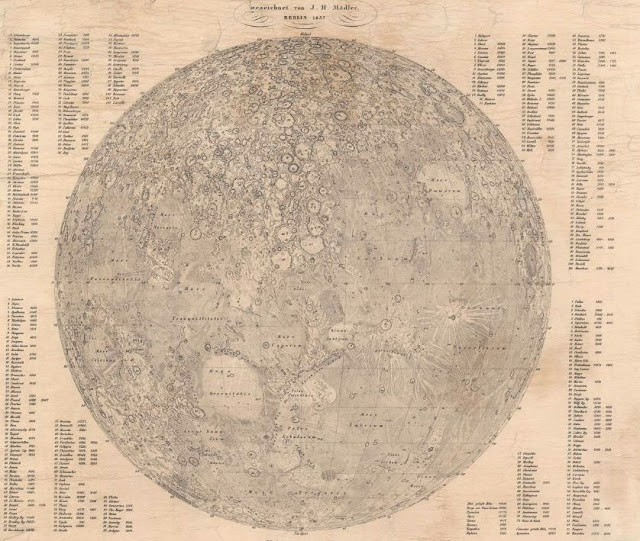
Mädler's 1837 version of the Moon map. High resolution version available at Geographicus.

So it turns out there actually was a highly detailed map of the moon as described by Andersen that could be used as a scientific basis for fictional landing sites. 

References